The recent operational training conducted by the Philippine Coast Guard (PCG) on maritime zones and archipelagic sea lanes reflects a commendable effort to translate newly enacted laws into actionable doctrine. Anchored on Republic Act No. 12064 and Republic Act No. 12065, the initiative signals the country’s commitment to a rules-based maritime order.
Yet beneath this progress lies a critical issue: the absence of officially published nautical charts and internationally recognized sea lanes, without which enforcement risks becoming legally vulnerable and operationally inconsistent.
While RA 12064 and RA 12065 are already enacted, the Philippines has yet to fully operationalize these laws through officially promulgated nautical charts, widely disseminated implementing rules, and internationally recognized archipelagic sea lanes.
A Law Without Coordinates Is a Law Difficult to Enforce
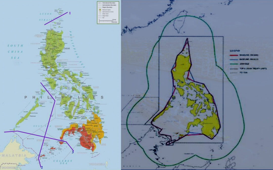
Maritime law enforcement is not exercised in theory—it is executed through precise geographic coordinates plotted on authoritative charts. While RA 12064 defines the Philippines’ maritime zones in legal terms, and RA 12065 establishes the framework for Archipelagic Sea Lanes (PASL), neither law has yet been fully operationalized through official chart publication.
This gap creates several immediate challenges:
- Ambiguous Jurisdiction at Sea – PCG units cannot definitively assert whether a vessel is within a specific maritime zone without officially recognized charts.
- Weakened Legal Standing – Apprehensions and interdictions risk being challenged due to lack of formally promulgated geographic references.
- Due Notice Concerns – Foreign vessels may claim absence of proper notification.
- Operational Hesitation or Overreach – Personnel may either hesitate or act beyond defensible limits.
In effect, enforcement becomes interpretive rather than authoritative—a dangerous condition in contested maritime spaces.
A Personal Lesson from the Field: The Cost of Undefined Boundaries
This legal–operational gap is not theoretical—it has been experienced in real-world command.
In 2008, while serving as Commanding Officer of DA-BFAR MCS 3004 under the Bureau of Fisheries and Aquatic Resources, a request was raised by fishing companies based in General Santos City. They sought the deployment of MCS vessels along the RP–Indonesia maritime border to protect Filipino fishermen from alleged harassment by Indonesian naval forces.
At that time, however, Republic Act No. 9522 had not yet been enacted. The Philippines’ maritime limits were still broadly referenced to the Treaty of Paris 1898, which did not provide operationally usable maritime zone delineations.
In contrast, Indonesia had already established clearly demarcated maritime zones reflected in official nautical charts, giving their enforcement units a decisive legal and operational advantage.
Faced with this disparity, a serious legal concern was raised to then BFAR Administrator, Atty. Malcolm “Boy” Sarmiento, Jr.
How can we deploy and enforce in a maritime boundary that is not clearly defined and officially charted?
The implications were clear:
- Any enforcement action could be interpreted as encroachment
- Personnel could be exposed to legal and diplomatic risk
- The Philippines would be operating from a position of legal ambiguity
With this structural gap unresolved, the request of the fishing companies had to be denied, despite the legitimate need for protection.
That decision underscored a fundamental truth: Operational courage cannot substitute for legal clarity.
The PASL Dilemma: Domestic Law vs International Recognition
The challenge persists today in another form. Under the United Nations Convention on the Law of the Sea, archipelagic sea lanes must be both designated by the State and recognized internationally through the International Maritime Organization.
Without this process:
- PASL remains domestically declared but internationally unenforceable
- Foreign vessels may legally exercise navigation rights outside designated routes
- Enforcement risks being challenged as inconsistent with international law
Thus, RA 12065, while progressive, remains incomplete without international validation.
Training Progress, but Structural Gaps Remain
The PCG’s initiative demonstrates institutional readiness. However, training must be matched with operational instruments and legal infrastructure.
Otherwise, the country risks repeating past constraints—only this time under a more complex and contested maritime environment.
Strategic Recommendations: From Law to Enforceability
To bridge this gap, the Philippine government must adopt a decisive, coordinated approach:
1. Immediate Charting and Official Publication
The National Mapping and Resource Information Authority must:
- Produce authoritative nautical charts for all maritime zones under RA 12064
- Plot exact coordinates of PASL under RA 12065
- Publish through the Official Gazette, Notices to Mariners, and international hydrographic channels
2. Formal Submission to the IMO
Through the Department of Foreign Affairs:
- Submit PASL proposals to the International Maritime Organization
- Engage diplomatically for recognition and adoption
3. Issuance of Implementing Rules and Regulations (IRR)
Develop unified IRR that:
- Define enforcement protocols
- Establish clear rules of engagement
- Harmonize inter-agency operations
4. Integration into Operational Systems
Equip PCG vessels with:
- Digitized maritime boundary overlays
- Real-time jurisdictional awareness tools
5. Global and Domestic Notification
Ensure dissemination through:
- Notices to Mariners
- NAVAREA advisories
- Integration into global shipping systems
6. Institutional Coordination Mechanism
Create an inter-agency body (PCG, NAMRIA, DFA, DOJ, DOTr) to ensure synchronized implementation and to prepare and submit internationally compliant documentation to the International Maritime Organization (IMO) in order to secure the recognition and adoption of the Philippines’ Archipelagic Sea Lanes.
Conclusion: Learning from the Past, Securing the Future
The experience in 2008 demonstrated the real-world consequences of enforcing maritime law without clearly defined and published boundaries. Today, despite stronger legislation, the same structural vulnerability risks re-emerging.
Until maritime zones are charted and published, and Archipelagic Sea Lanes are internationally recognized, the Philippine Coast Guard will remain constrained—not by lack of capability, but by lack of legal-operational tools.
The lesson is enduring:
A nation must not only declare its maritime domain—it must define it, publish it, and have it recognized by the world.
Only then can enforcement shift from cautious restraint to confident, lawful, and effective maritime governance.
References
- Republic Act No. 12064 (2024). An Act Defining the Maritime Zones of the Philippines.
- Republic Act No. 12065 (2024). An Act Providing for the Designation of Archipelagic Sea Lanes.
- Republic Act No. 9522 (2009). An Act to Amend Certain Provisions of RA 3046.
- United Nations Convention on the Law of the Sea (1982).
- International Maritime Organization. Ships’ Routing and Archipelagic Sea Lanes Processes.
- National Mapping and Resource Information Authority. Nautical Charting and Maritime Boundary Delineation Mandate.
- Treaty of Paris 1898.
- Bureau of Fisheries and Aquatic Resources. Monitoring, Control and Surveillance (MCS) Framework.
- Philippine Coast Guard. Maritime Law Enforcement Training Initiatives (2026).
Indeed, Sir! IMO adoption is essential for us to realize one of the primary benefits of the archipelagic regime in UNCLOS, that is legal clarity on which PH waters are navigable by innocent passage and archipelagic sea lanes passage