How Ocean Monitoring Buoys Could Transform Sea Travel in the Philippines
For millions of Filipinos, traveling by sea is not a choice—it is a necessity.
Every day, ferries, Roll-on/Roll-off (RoRo) vessels, cargo ships, and motorized boats transport passengers, food, fuel, medicine, construction materials, and countless other goods between islands. In a country composed of more than 7,600 islands, maritime transportation serves as the lifeline that keeps communities connected and the economy moving.
Yet every year, rough seas, tropical cyclones, and monsoon weather disrupt maritime operations. Sailings are suspended, ports become congested, cargo deliveries are delayed, and travelers are stranded. While these restrictions are often necessary to protect lives, they can also create significant economic and social consequences.
The challenge is that weather forecasts do not always tell the whole story.
A storm affecting one part of the country may not necessarily create dangerous conditions along another shipping route. Likewise, even when no storm signal is raised, localized sea conditions can become hazardous due to strong winds, currents, or high waves.
This is where a new maritime safety initiative called the National Oceanographic Buoy-Based Maritime Departure Decision Support System (NOB-MDDS) can make a difference.
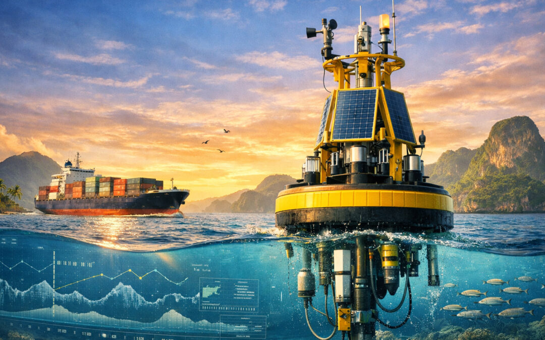
Understanding What Is Really Happening at Sea
Imagine having weather stations floating in strategic sea areas across the Philippines.
These oceanographic buoys continuously measure actual conditions at sea, including wind speed, wave height, wave direction, sea currents, atmospheric pressure, rainfall, and visibility.
Instead of relying solely on forecasts, maritime authorities would have access to real-time information from the actual route where vessels intend to travel.
The information would be transmitted to a National Oceanographic Center and shared with the Philippine Coast Guard, shipping companies, port operators, logistics providers, and other maritime stakeholders.
In simple terms, the system allows decision-makers to know not only what the weather might be, but also what is actually happening on the water.
Strategic Deployment Along Critical Maritime Corridors
The effectiveness of the NOB-MDDS depends on the strategic placement of oceanographic buoys in areas that experience heavy vessel traffic, challenging sea conditions, and significant economic activity.
Priority deployment areas may include:
- San Bernardino Strait;
- Surigao Strait;
- Manila Bay;
- Davao Gulf;
- Tawi-Tawi Sea;
- Palawan Sea;
- General Santos Bay; and
- Cebu Strait.
These waterways are among the most important maritime corridors in the country. They serve as major routes for passenger vessels, RoRo operations, cargo transportation, fishing activities, and international trade.
By monitoring actual sea conditions in these critical areas, maritime authorities can make route-specific decisions that improve both safety and efficiency.
Safer Travel for Passengers
For the riding public, the most important benefit is safety.
Every voyage decision would be supported by real-time oceanographic information. Dangerous routes can be identified more quickly, allowing authorities to suspend sailings before conditions become life-threatening.
At the same time, routes that remain safe despite weather disturbances elsewhere may continue operating.
This means safer and more accurate decisions that protect passengers while avoiding unnecessary disruptions.
The goal is straightforward: fewer maritime accidents, better protection of lives, and greater confidence in sea travel.
Greater Reliability for Shipping Companies
For shipowners and vessel operators, weather-related uncertainty often results in operational losses.
When voyages are canceled unnecessarily, operators lose revenue. Cargo schedules are disrupted, vessels remain idle, and operating costs continue to accumulate.
With real-time oceanographic monitoring, departure decisions can be based on actual sea conditions rather than broad regional assessments alone.
This allows shipping companies to plan voyages more effectively, improve schedule reliability, and reduce avoidable operational disruptions.
More accurate information means better business decisions.
Strengthening Supply Chains
The impact extends far beyond ports and vessels.
When maritime transportation is interrupted, food, fuel, medicine, agricultural products, and other essential commodities are affected.
Delays can increase transportation costs, affect inventories, and disrupt business operations.
For logistics providers and supply chain managers, reliable maritime transportation is essential.
By helping vessels sail safely whenever conditions permit, the proposed system can reduce bottlenecks, improve cargo movement, and strengthen supply chain resilience across the country.
Supporting Economic Growth
The Philippine economy depends heavily on inter-island trade.
Manufacturers need raw materials. Retailers require inventory. Farmers depend on access to markets. Consumers rely on the timely delivery of goods.
A more reliable maritime transportation system benefits all of them.
Reducing unnecessary voyage suspensions means lower transportation costs, improved business continuity, and increased economic efficiency.
In effect, safer and smarter maritime operations contribute directly to national economic growth.
Helping Coast Guard Personnel Make Better Decisions
Another important benefit is the support the system provides to Philippine Coast Guard personnel.
Today, Coast Guard commanders often face difficult decisions regarding vessel departures during adverse weather conditions. These decisions carry significant responsibility because public safety is involved.
The proposed system provides an objective and transparent basis for decision-making through real-time oceanographic observations and standardized risk assessments.
Instead of relying solely on forecasts and local observations, decision-makers can use verified data from the actual route of voyage.
This strengthens accountability while improving public confidence in maritime safety decisions.
The system also complements the implementation of Philippine Coast Guard Memorandum Circular No. 02-23 (Revised Guidelines on the Movement of Vessels During Heavy Weather) and Philippine Coast Guard Memorandum Circular No. 03-01 (Guidelines on the Movement of Motorboats/Vessels in the Absence of Weather Bulletins in the Locality), which currently guide vessel departure decisions throughout the country.
A Sustainable Investment in Maritime Safety
For the NOB-MDDS to remain effective over the long term, the oceanographic buoy network must be continuously maintained, calibrated, upgraded, and expanded.
This requires a sustainable funding mechanism beyond annual government appropriations.
One practical approach is the establishment of a Maritime Safety Information Service Charge (MSISC) integrated into the vessel departure clearance process. The charge would be minimal compared to overall voyage costs and would be borne primarily by commercial beneficiaries of the system, including shipping companies, cargo operators, and other maritime enterprises.
The revenues generated would be deposited into a dedicated Oceanographic Buoy Trust Fund and used exclusively for:
- Maintenance and repair of oceanographic buoys;
- Calibration and replacement of sensors;
- Communication and data transmission systems;
- Expansion of buoy coverage to additional maritime corridors;
- Research and development activities;
- Personnel training and capability development; and
- Modernization of the National Oceanographic Center.
In essence, the users who directly benefit from improved maritime safety and voyage reliability would help sustain and expand the very system that supports their operations.
A Long-Term Investment in Maritime Safety
The proposed National Oceanographic Buoy-Based Maritime Departure Decision Support System is more than a technology project.
It is an investment in safer travel, stronger supply chains, more reliable commerce, and better maritime governance.
The system also supports broader national initiatives such as Vessel Traffic Management Systems (VTMS), Maritime Domain Awareness, climate resilience programs, search and rescue operations, and the institutionalization of Philippine Archipelagic Sea Lanes.
Most importantly, it reflects a simple but powerful principle:
Maritime decisions should be based not only on forecasts of what might happen, but also on real-time knowledge of what is actually happening at sea.
Looking Ahead
As the Philippines continues to modernize its maritime sector, investing in real-time oceanographic intelligence can help transform how vessel departure decisions are made.
For passengers, it means safer travel.
For shipowners, it means greater operational reliability.
For logistics companies, it means stronger supply chains.
For government, it means better governance and improved public safety.
And for the nation, it means a more resilient maritime transportation system capable of supporting economic growth and national development across the archipelago.
The future of maritime safety may not depend solely on watching the weather—it may depend on understanding the sea itself.
References
- Philippine Coast Guard. Memorandum Circular No. 02-23 (23 March 2023), Revised Guidelines on the Movement of Vessels During Heavy Weather.
- Philippine Coast Guard. Memorandum Circular No. 03-01 (02 February 2001), Guidelines on the Movement of Motorboats/Vessels in the Absence of Weather Bulletins in the Locality.
- Philippine Atmospheric, Geophysical and Astronomical Services Administration (PAGASA). Tropical Cyclone Information, Marine Meteorological Services, and Climatological Data.
- International Maritime Organization (IMO). International Convention for the Safety of Life at Sea (SOLAS), 1974, as amended.
- World Meteorological Organization (WMO). Guide to Marine Meteorological Services (WMO-No. 471).
- National Oceanic and Atmospheric Administration (NOAA). National Data Buoy Center (NDBC): Ocean Observation and Marine Weather Monitoring Systems.
- Intergovernmental Oceanographic Commission of UNESCO (IOC-UNESCO). Global Ocean Observing System (GOOS) Framework and Ocean Observation Best Practices.
- Maritime Industry Authority (MARINA). Domestic Shipping Safety Regulations and Vessel Safety Standards.
- National Mapping and Resource Information Authority (NAMRIA). Hydrographic and Oceanographic Services for Maritime Safety.
- National Disaster Risk Reduction and Management Council (NDRRMC). National Disaster Risk Reduction and Management Plan.
- Department of Transportation (DOTr). Maritime Transport Development Policies and Programs.
- Beaufort, Francis (1805). Beaufort Wind Force Scale, adopted internationally for marine weather observation and maritime operations.